Category:River Suir Bridge
Jump to navigation
Jump to search
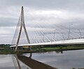
Deutsch: Die River Suir Bridge überspannt bei Waterford in Irland den Fluss Suir. Die Straßenbrücke wird nach der Fertigstellung im Jahr 2009 mit zwei Fahrstreifen je Fahrtrichtung Teil der Nationalstraße N25 sein, die auf einer neuen Trasse Waterford umgehen wird. Die einhüftige Schrägseilbrücke wird mit 230 m die größte Stützweite einer Brücke in Irland aufweisen.
English: The River Suir Bridge is a cable-stayed bridge over the River Suir in Ireland. It was built as part of the N25 Waterford Bypass, and opened to traffic on the 19 October 2009, some ten months ahead of schedule. The Viking settlement at Woodstown was discovered during the project and the route of the southern approach roads was altered to preserve the site.
cable-stayed bridge .jpg) | |||||
| Upload media | |||||
| Instance of | |||||
|---|---|---|---|---|---|
| Named after |
| ||||
| Location |
| ||||
| Crosses | |||||
| Carries | |||||
| Inception |
| ||||
| Date of official opening |
| ||||
| Length |
| ||||
 | |||||
Media in category "River Suir Bridge"
The following 15 files are in this category, out of 15 total.
-

-
 Dillon Bridge Plaque.jpg 4,032 × 3,024; 4.69 MB
-
 Farmland at Gracedieu - geograph.org.uk - 1392668.jpg 640 × 480; 226 KB
-

-
 New Bridge - geograph.org.uk - 1388098.jpg 600 × 450; 193 KB
-
 New bridge - geograph.org.uk - 962791.jpg 640 × 480; 155 KB
-
 Rail and Road Bridges - geograph.org.uk - 1389448.jpg 576 × 414; 138 KB
-
 River Suir Bridge - geograph.org.uk - 1365530.jpg 480 × 640; 86 KB
-
 River Suir Bridge, Waterford.jpg 4,746 × 2,563; 3.97 MB
-
 River Suir Bridge1.jpg 2,145 × 1,776; 2.1 MB
-
 River Suir Bridge2.jpg 4,000 × 3,000; 4.61 MB
-
 River-Suir-Bridge.jpg 3,456 × 2,304; 874 KB
-
 Stringed Instrument - geograph.org.uk - 1388103.jpg 600 × 450; 209 KB
-
 Suir Bridge.JPG 3,000 × 4,000; 2.76 MB
-
 Suir RiverBridge looking south(Edit).jpg 1,280 × 960; 566 KB


